GAC Trainings
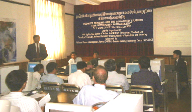
GIS Application Center (GAC) conducted a Course on Remote Sensing and GIS Advanced Training for Watershed Management in Lao PDR from June 3-7, 2002.
The training program was a joint effort of Asian Institute of Technology, National University of Lao and the Lao Ministry of Agriculture and Forestry. The program was partially sponsored by the National Space Development Agency of Japan (NASDA).
Twenty participants from various Government Organizations participated. Dr. Sohan Wijesekera, Chairman of GAC; Dr. Kiyoshi Honda of the Space Technology Applications and Research (STAR) Program; Ms. Kulapramote Pratumchai of GAC were the resource persons from AIT.

At The Opening Day
June 24 July 5, 2002: GIS Application Center (GAC) successfully completed a training program on GIS and Remote Sensing for Coastal Zone Management. This program was partially supported by the National Space Development Agency of Japan. In his opening address, Dr. Sohan Wijesekera, Chairman GIS Application Center, thanked Prof. H.N. Phien Dean, SAT, Prof. Michiro Kusanagi, STAR Program Coordinator, Dr. Kiyoshi Honda and Dr. Nitin Tripathi of STAR Program and Dr. Sutat Weerasakul of Water Engineering and Management Program, SCE, for gracing the occasion. At the opening ceremony, Prof. Phien congratulated the GIS Application Center for its capacity building in Geoinformatics in the Asia-Pacific Region. The course was conducted for 17 participants from 6 countries in the region.

